2020 Year in Review
Wildfire Response Tests xView2 Damage Assessment Prototype
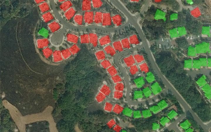
Assessing building damage is a critical first step when natural disasters strike. xView2, a machine-learning (ML) computer vision system, speeds this process by using satellite imagery to classify damage to structures. In a busy 2020 wildfire season, multiple disaster response agencies received an xView2 prototype for testing.
xView2 sprang from a Defense Innovation Unit (DIU) 2018 competition that focused on accelerating progress in four computer vision frontiers: reduce minimum resolution for detection, improve learning efficiency, enable discovery of more object classes, and improve detection of fine-grained classes. To build on this initial work, xView2 contestants built ML algorithms that scanned satellite photos of disaster-struck areas and classified building damage.
An SEI team worked with the DIU team to create the challenge, the baseline ML models, a building damage scale, and xBD, a database of satellite photos with human-labeled building damage, against which competitors’ ML results would be judged. After the competition, the SEI packaged the best ML models into a prototype tool.
Generally speaking, an analyst would take an entire day or two to clear a large fire area […] xView could assess it in less than 10-20 minutes.
Chief Manuel Villalba
Intelligence analyst, California National Guard
In 2020, the California National Guard preliminarily tested the xView2 prototype during the massive August Complex fire and smaller Valley fire. “Generally speaking, an analyst would take an entire day or two to clear a large fire area containing hundreds of structures,” said Chief Manuel Villalba, a California National Guard intelligence analyst specializing in wildfires. “According to our testing, it’s possible xView could assess it in less than 10-20 minutes.”
To learn more about xView2, visit sei.cmu.edu/our-work/projects/display.cfm?customel_datapageid_4050=295280.
Photo: California Bureau of Land Management
Photo: Raw image Copyright 2019 Maxar/DigitalGlobe. Used under a Creative Commons Attribution-NonCommercial 4.0 license (CC BY-NC 4.0). Polygons added by Carnegie Mellon University Software Engineering Institute.
Researchers
Ritwik Gupta, Ricky Hosfelt, Eric Heim
More on Artificial Intelligence Engineering from the 2020 Year in Review

Navigation Demonstration Flips the Script on Machine Learning in Naturalistic Scenarios
The inverse reinforcement learning (IRL) method predicts behavior and detects anomalies in open-world, naturalistic scenarios.
READ MORE
National Initiative Forges the Path to an Engineering Discipline for AI
The Software Engineering Institute (SEI) will lead a National AI Engineering Initiative with funding and guidance from the Office of the Director of National Intelligence (ODNI).
READ MORE
Game-Based Design Improves AI Support of Human Decision Making
After observing several deployed AI decision support systems, Rotem Guttman noticed a common issue. “Humans make poor choices..."
READ MORE
AI Collaboration Supports U.S. Army Operations
The Army selected Carnegie Mellon University (CMU) to become the hub of the U.S. Army’s Artificial Intelligence Task Force (AITF).
READ MORE